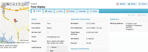
Our organization thought it would be cool to embed a map of the account billing address where the household picture normally goes. I thought this wouldn’t be too difficult, but I don’t know a lot of jQuery so I’m a bit stuck. Here’s the code I do have (which obviously doesn’t work), but may give you an idea of what we’re looking to do. vskuid.componentType.register(‘mapAddress’,function(element){ // instantiate a model using the model named “Accounts” var m = skuid.model.getModel(‘Account’); // get the first row (or record) from our model var row = m.getFirstRow(); // assemble the mailing address fields var street = m.getFieldValue(row,‘BillingStreet’); var city = m.getFieldValue(row,‘BillingCity’); var state = m.getFieldValue(row,‘BillingState’); var zip = m.getFieldValue(row,‘BillingPostalCode’); var address = street + ’ ’ + city + ', ’ + state + ’ ’ + zip; < iframe src=“http://www.google.com/q=address” > });
This topic has been closed for comments
Enter your E-mail address. We'll send you an e-mail with instructions to reset your password.


