Nintex Community Menu Bar

I am trying to make a Geo Chart on all the Accounts we have in NZ, when I preview the page nothing shows up.
We use the standard Salesforce Picklists, I have checked the data and it is there. 
Why would it not be showing up. 

Hello Rhyannon,

I am going to try to recreate this today to help find a solution. Is this pulling from standard objects? If so, could you share the XML, I could add the page to a dev environment to debug.


Otherwise, I will try to reproduce a similar setup as best as possible. What version of Skuid are you running at the moment?

Thanks,
Clark


I almost meant to ask… Are you trying to create a map of just New Zealand and have the accounts divided by province?


#b39ddb
#9575cd
#7e57c2
#673ab7
#5e35b1
#512da8
#4527a0

Yes I am. I wanted a map of where all out accounts are.


Thanks Rhyannon,


I have a NZ geochart working on a page in our demo org— it appears that we have some different field names in our orgs. But, I think the idea behind the fields are the same.


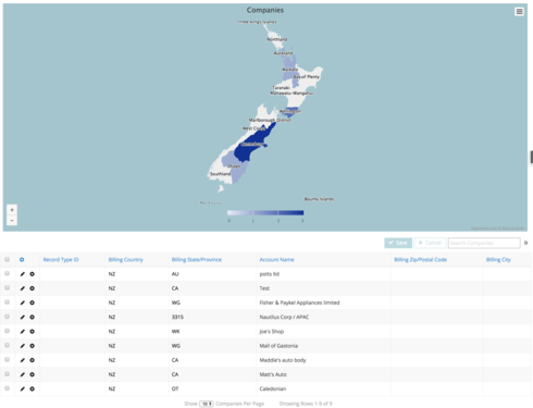
I can think of 2 other items to check off the top of my head. I see your “Accounts” model does not have a condition to limit it to NZ accounts. That may help in pulling in the correct data to display. Secondly, Highcharts has a somewhat specific format that it is looking for the information to be provided in. I would check the underlying data in the fields being used to ensure that the Country code is “NZ” and that the State/Province uses the following abbreviations in quotes:


‘au’ -

‘ma’

‘so’

‘wk’

‘wg’

‘4680’ (This is for Bounty Islands)

‘6943’ (This is for Three Kinds Islands)

‘6947’ (This is for The Snares)

‘ca’

‘ot’

‘mw’

‘gi’

‘hb’

‘bp’

‘no’

‘tk’

‘wc’


See screenshot below for an example:


Does this line up with the data in your database? Apologies for not having a better knowledge of New Zealand geography. Let em know if you have any additional questions or if this isnt very clear.


Thanks,

Clark


Thanks so much Clark, I got it working!