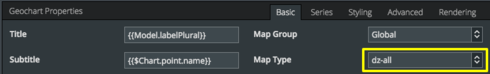
I’ve Geochart inside the Chart Set. I’m trying to figure out what is this map type called “dz-all” (see below snapshot) in the Geochart Properties.
Could anybody provide me with the information or the resource somewhere I could look into.
Thanks!

I’ve Geochart inside the Chart Set. I’m trying to figure out what is this map type called “dz-all” (see below snapshot) in the Geochart Properties.
Could anybody provide me with the information or the resource somewhere I could look into.
Thanks!
Priya
Those are country codes. Check: https://developers.google.com/chart/interactive/docs/gallery/geochart for references. DZ stands for Algeria.
In the linked article are all country codes available.
Janick
Enter your E-mail address. We'll send you an e-mail with instructions to reset your password.